Geosteering Powered by Machine Learning
Three things to know about Factor Drive
It’s a probabilistic world
Every geosteerer knows that the best type log to LWD correlation doesn’t guarantee the best geologic structure. Tasked with coming up with a single answer, you sometimes try two or more cases to judge the best one. You’re doing probabilistic Bayesian inference! But you have limited tools that don’t help you make the best decisions under uncertainty.
Factor Drive gives you the power of quantitative information you use to make the best possible steering decisions.

Factor Drive’s reasoning engine
Factor Drive applies a physics-based machine learming technology called a Bayesian network. A Bayesian network is a probabilistic model that organizes data and knowledge into interconnected relationships. Bayesian networks have been used in robotics and autonomous vehicles to make decisions under uncertainty. By "physics-based" we mean that the algorithm understands and honors the physics of geosteering; we do not need to train it to geosteer on a corpus of data. Read the full technical details here. The Bayesian network enables Factor Drive to solve the huge combinatorial problem of finding the most probable structure that satisfies all the constraints, and to develop a picture of the uncertainty in the answer.Only Factor Drive, using this technology, can exhaustively explore all the possible geologic structures and rank them by their probability. .
Reason like a person
Factor Drive assembles all your prior information about the geologic structure, the stratigraphy, and the measurement accuracy to calculate the most probable structure that satisfies those constraints. That’s the way people geosteer. For each constraint, you tell Factor Drive a probability. You may know the regional apparent dip in this area is 91°. But you also tell Factor Drive about your confidence in that number. You express that confidence as dip sigma. This sigma is the standard deviation of a normal distribution. A rule of thumb is that three sigma is 99.7% confidence. So if you tell Factor Drive the regional dip is 91° with 3° dip sigma, you’re 99.7% confident the dip is between 82° and 99°. You allow Factor Drive to vary the dip in that range, but penalize the larger variations from 91°.
That’s one way to specify your prior idea of the dip, but another way is to upload a structure file, or grid. Factor Drive extracts the laterally-varying apparent dips from that grid, then applies your dip sigma to them, to constrain its answer. Factor Drive uses the prior dip, either from a regional apparent dip or a structure file, as a loose guide to the shape you expect the structure to take, based on your experience in the area.
As another example, take the gamma ray log and the type log. The type log represents your prior idea of the stratigraphy, but it’s notexactly the same as the stratigraphy you’re drilling through. Even when the stratigraphies are very close, there can be large statistical variations in gammma counts between the two logs. You would never expect a perfect correlation. Tell Factor Drive how closely or loosely it must match the LWD gamma to some value on the type log. Again you use a log sigma, and as before this sigma is the standard deviation of a normal distribution. So if you specify a log sigma of 10 API units, you’re 99.7% confident the LWD gamma will be within 30 API units of the type log gamma. (Advanced topic: you may instead use a more forgiving Laplace distribution for noisier data.)
Those are constraints you can tell Factor Drive before you make any actual measurements (LWD gamma and directional surveys). As you drill, Factor Drive incorporates these measurements and reasons out the possible geologic structures that could produce them. Think of your constraints as having a little “wiggle room”, in the form of the sigmas, Factor Drive can use to adjust things all along the wellbore to find all the best structures. As the well grows laterally, new information arrives from the toe of the well, and Factor Drive incorporates it with all the previous measurements, your constraints, and the wiggle room you allow. Watch closely and you’ll see Factor Drive sometimes modify the calculated structure far back along the lateral to better match the new data.
But there is not just one answer to the geosteering ill-posed problem. There may be many possible structures that satisfy the constraints. It’s a huge combinatorial problem. Try adjusting dip here, and you now must adjust the dip there, there, and there. And so on. A person can explore a small part of this space. But only Factor Drive, using its Bayesian network, can reason about all those permutations and show you the best ones.

The marginal probability field
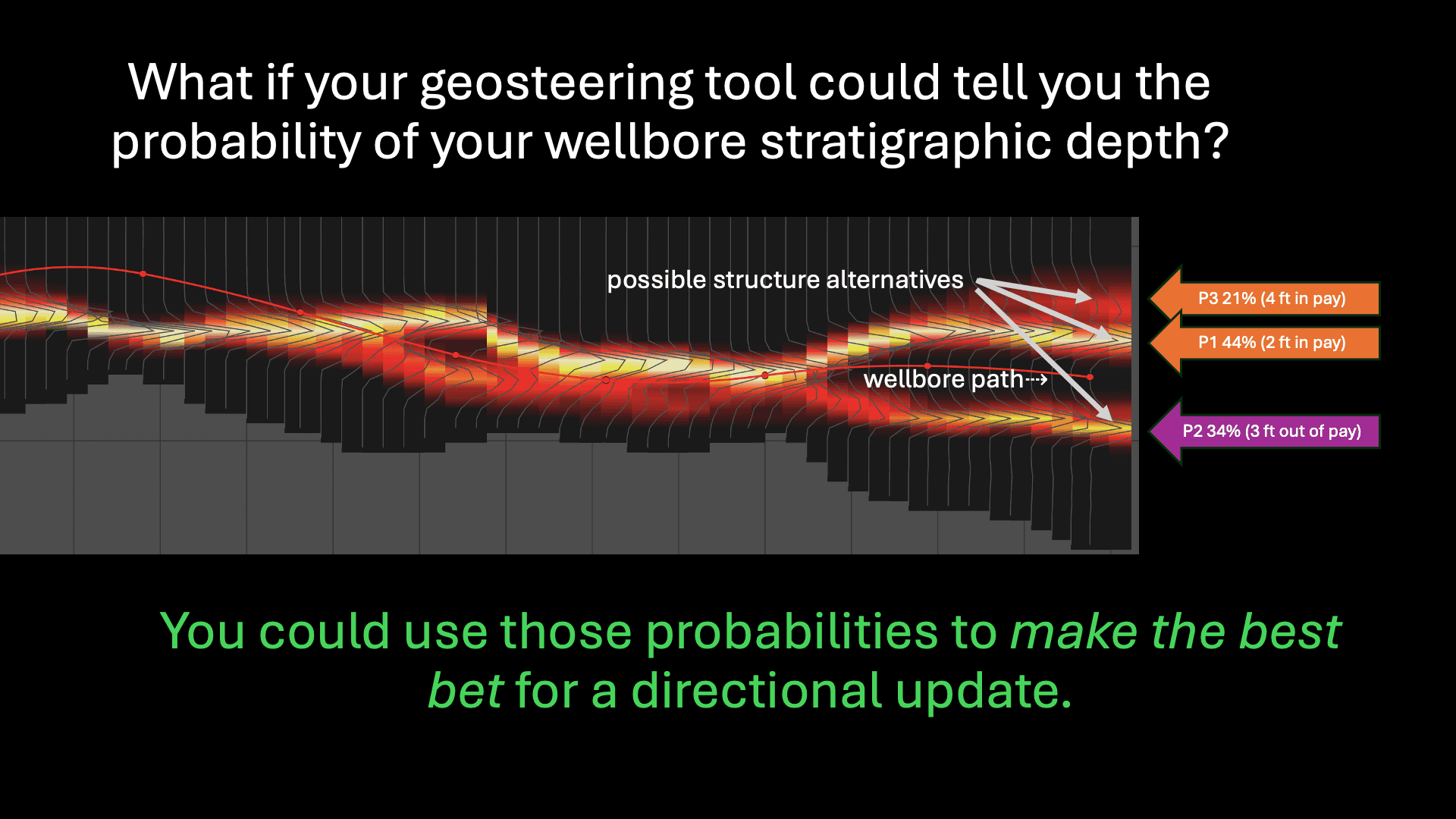
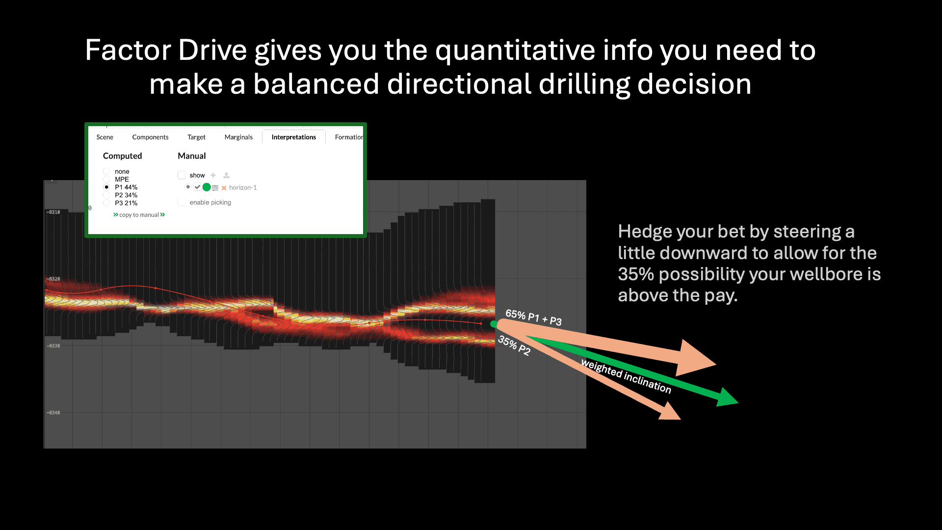
As part of its answer, Factor Drive computesposterior marginal probabilities representing the probability that the geologic structure passed through any given x, z point. ("Posterior" refers to the probability after the system has seen the measurements. "Marginal" refers to the probability of the structure passing through a point, regardless of the structure elsewhere.) It displays these marginals a heat map. Think of the marginals as a way to visualize the uncertainty in the structure. They can also illuminate alternative structures that you should consider. Just because a solution is the most probable answer doesn’t mean it’s the correct answer. For example, the most probable structure might have a 40% probability. That means there’s a 60% chance it’s wrong. If two other possible structures lie close to one another and combine for 50% probability, you might be better off selecting one of them. There’s plenty of room to apply your experience and judgment to make decisions with Factor Drive. But now you have quantitative information to guide you.
Come for the automation. Stay for the insight.
You probably got interested in Factor Drive because automation promises relief from the stress and effort of geosteering. But what’s the use of automation without robust, reliable results?
And Factor Drive goes beyond reliability to compute geologic insights you can’t get using traditional geosteering tools.So Factor Drive is also cloud-based service you can run 24/7. You can connect it to WITSML services and update an interpretation continuously for days on end.
Whether you’re a consultant resteering a well or a large operator running a fleet, Factor Drive scales to your size. Experience the freedom of hands-free geosteering.